Wesdome Defines 10 Kilometres of Prospective Strike and Expands Near-Surface Mineralization at Eagle River
New structure opens up 10 kilometres of potential strike length along the Mishibishu Deformation Zone; 2026 drilling will focus on validating new interpretation and identifying similar structures across the land package
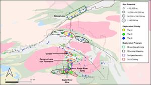
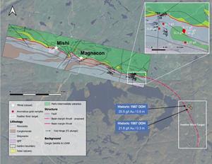
TORONTO, Dec. 15, 2025 (GLOBE NEWSWIRE) -- Wesdome Gold Mines Ltd. (TSX:WDO, OTCQX:WDOFF) (“Wesdome” or the “Company”) today provides an update on its surface exploration activities at its wholly-owned Eagle River mine (“Eagle River”) near Wawa, Ontario, Canada (Figure 1).
Anthea Bath, President and Chief Executive Officer, commented, “The extensive work undertaken on Eagle River’s regional targets has yielded encouraging results, including a new interpretation at Mishi and Magnacon that opens up 10 kilometres of potential strike length for exploration along the Mishibishu Deformation Zone. Long-term target generation at Eagle River has taken a major step forward this year, powered by the detailed structural mapping program we launched in mid-2024. We’re now seeing that systematic groundwork is beginning to pay off, reshaping how we approach exploration across several key targets. Underground, our team has been fully committed to the first phase of global model drilling, and the results to date are validating our early interpretations. We remain on track to finish this phase ahead of the drilling cutoff for the year-end technical report. With everything coming together, momentum is building and we’re excited to carry it into an expanded regional exploration program next year.”
Jono Lawrence, Senior Vice President Exploration and Resources, added, “A significant portion of gold deposits in the Abitibi Greenstone Belt are hosted within metasedimentary packages or preserved structural footwalls of thrust systems, and this is exactly what we are seeing at Mishi. Based on surface samples collected in 2025, together with historical drilling, we potentially have a high-grade thrust system to the south of the Mishibishu Deformation Zone. Confirming the system’s presence is now a top priority for our 2026 exploration program.”
HIGHLIGHTS
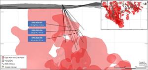
Mishi Zone (Figure 2, Table 1)1
Drilling extends strike length and confirms potential for depth extensions
- Hole MSH-2025-024: 6.4 g/t Au uncapped over 2.5 m core length (6.4 g/t Au capped, 2.3 m true width) and,
- 8.3 g/t Au uncapped over 4.7 m core length (8.3 g/t Au capped, 4.5 m true width) including,
- 16.3 g/t Au uncapped over 1.0 m core length
- 18.3 g/t Au uncapped over 0.8 m core length
- 8.3 g/t Au uncapped over 4.7 m core length (8.3 g/t Au capped, 4.5 m true width) including,
- Hole MSH-2025-007: 5.7 g/t Au uncapped over 4.0 m core length (5.7 g/t Au capped, 3.9 m true width) including,
- 7.2 g/t Au uncapped over 0.5 m core length
- 9.0 g/t Au uncapped over 0.8 m core length
- Hole MSH-2025-019: 5.5 g/t Au uncapped over 3.5 m core length (5.5 g/t Au capped, 3.4 m true width) including,
- 35.1 g/t Au uncapped over 0.5 m core length
- Hole MSH-2025-028: 5.4 g/t Au uncapped over 3.1 m core length (5.4 g/t Au capped, 2.7m true width) including,
- 32.6 g/t Au uncapped over 0.4 m core length
- Hole MSH-2025-009: 3.8 g/t Au uncapped over 2.5 m core length (3.8 g/t Au capped, 2.5m true width) including,
- 7.2 g/t Au uncapped over 1.0 m core length
- Hole MSH-2025-008: 3.1 g/t Au uncapped over 6.5 m core length (3.1 g/t Au capped, 6.4 true width) including,
- 7.3 g/t Au uncapped over 0.5 m core length
- 7.3 g/t Au uncapped over 0.5 m core length
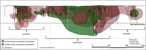
Dorset Zone (Figure 3, Table 1)3
Drilling builds on previous results and confirms that the deposit remains open at depth and along strike
- Hole GS-25-232: 2.2 g/t Au uncapped over 5.2 m core length
- Hole GS-25-239: 1.6 g/t Au uncapped over 8.9 m core length
Falcon 720 Zone (Figure 4, Table 1)2
Confirming eastern extension
- Hole ERS-2025-057: 10.0 g/t Au uncapped over 5.4 m core length (10.0 g/t capped, 4.0 m true width)
- Hole ERS-2025-055: 4.3 g/t Au uncapped over 2.3 m core length (4.3 g/t capped, 1.6 m true width)
- Hole ERS-2025-054: 3.9 g/t Au uncapped over 4.4 m core length (3.9 g/t capped, 3.3 m true width)
Cameron Lake Iron Formation (Figure 5, Table 1)3
Drilling supports work completed by Angus Gold; continues to intercept grades greater than 1.0 g/t over significant thickness and confirms that the deposit remains open at depth and along strike
- Hole GS-25-263: 1.1 g/t Au uncapped over 39.0 m core length
- Hole GS-25-264: 1.0 g/t Au uncapped over 88.6 m core length
1 Assays capped at 50.0 g/t for Mishi Zone.
2 Assays capped at 125 g/t for Falcon 720 Zone.
3 No top cut or true width defined.
TECHNICAL DETAILS
Regional Exploration
Wesdome’s exploration efforts across the 400 km² Eagle River land package have accelerated over the past six months. With the objective of advancing a diverse pipeline of targets at varying stages of drill readiness, the Company has been actively conducting structural mapping, grab sampling, ground geophysical surveys, and drilling across multiple high-potential areas of the property. This includes the entire Mishi-Magnacon trend within the Mishibishu Deformation Zone, as well as the Eagle River Splay-North Diorite area. Additionally, the Feather River and Abbey Lake areas have emerged as high-priority long-term targets based on newly interpreted structural features and encouraging historical work.
Mishi and Magnacon Historic Mine Areas
Significant progress has been made at the Mishi and Magnacon historic mine areas, which are being advanced as part of the global model program. A comprehensive drilling program was executed across the broader project area in 2025, with assay results currently being compiled as they are received.
At Mishi, a 9,600-metre program was designed to evaluate the deposit’s expansion potential and to support a future update to the mineral resource estimate. Key objectives included testing the down-plunge continuity of the mineralized zones, twinning priority historical intercepts, and evaluating untested gaps to the west of the existing open pit. Initial results are confirming that near-surface mineralization of favourable grade and thickness extends along strike for nearly one kilometre to the west of the current Mishi pit boundary, pointing to a meaningful opportunity to expand the known mineralized footprint.
Drilling has also reinforced the potential for extensions to the mineralized system at depth, with hole MSH-2025-024 intersecting 8.3 g/t Au (uncapped) over 4.7 metres of core length (8.3 g/t Au capped over 4.5 metres true width) beginning at a downhole depth of 325.6 metres. The same hole also intersected 6.4 g/t Au (uncapped) over 2.5 metres at shallower depth, indicating a potential parallel mineralized trend north of the established Mishi trend.
At Magnacon, a 3,200-metre drill program was completed in 2025 to collect critical structural information, twin select historical intercepts, evaluate geological concepts related to the controls of higher-grade mineralization, and confirm the positions of key historical underground workings. Drilling intersected the historic stopes as expected, confirming the historical data. These results, combined with ongoing surface geological and structural mapping, are expected to contribute to a separate updated geological and resource model in 2026. All assay results from Magnacon are pending.
Detailed mapping has been completed along a 10-kilometre strike length of the Mishi-Magnacon trend and has defined a newly interpreted basin margin thrust fault, accompanied by the identification of meta-conglomerates (Figure 6).
The well-defined position of this structural boundary is particularly significant, as gold mineralization within the Mishibishu Deformation Zone is consistently located in close proximity to this contact. The thrust marks the boundary between metasedimentary rocks to the south and metavolcanic rocks to the north. This is a critical interpretation as a significant portion of gold deposits throughout the Abitibi Greenstone Belt occur within the metasedimentary package or preserved structural footwalls of thrust systems rather than the volcanic units.
Notably, the known Mishi and Magnacon deposits sit within the metavolcanic package to the north of the structure, underscoring a compelling new exploration opportunity within the metasediments to the south. Newly collected grab samples from the 2025 field season, taken south of the basin margin contact, and within the metasedimentary package, four kilometres to the east of the Magnacon deposit, returned anomalous values of up to 51.5 g/t, further reinforcing the untapped potential of this setting.
This structural interpretation also strengthens the exploration opportunity at the Feather River target, located eight kilometres to the east of Magnacon on the Mishibishu Deformation Zone. The target straddles the interpreted eastern extension of the basin margin thrust, aligning it with the new geological model. Historical drilling in this area includes intercepts of 0.9 metres at 20.5 g/t Au (historic hole M-160) and 0.3 metres at 21.8 g/t Au (historic hole M-155). Minimal drilling has been completed south of the interpreted thrust in this area, and a proof-of-concept drill program has been incorporated into the exploration budget for 2026.
The newly recognized significance of the contact between the mafic volcanics and sedimentary rocks along the Mishibishu Deformation Zone also underscores the importance of further evaluating the volcanic–sedimentary contact present at the Dorset Zone. This same contact hosts Dorset West, the highest-grade portion of the currently defined gold zone.
In addition, consistently mapped shallow, eastward-plunging fold hinges along the Mishibishu Corridor (Figure 6) highlight a potential structural control on mineralization, an important development as the amount of down-plunge drilling accelerates at the Mishi deposit, where strong potential exists to expand the mineralized zone. This structural framework also appears significant at Dorset, where recent drilling was planned to test an easterly plunge to the mineralization. Drillhole GS-25-208 successfully intersected 1.8 g/t Au over 19.0 metres, including 6.0 g/t Au over 5.3 metres (see the Company’s press release dated September 3, 2025). While additional mapping is required to refine the structural model at Dorset, the emerging similarities are encouraging as property-scale exploration becomes an increasing focus at the Eagle River Project.
Dorset Zone
More than 14,000 metres of drilling was completed across Dorset in 2025, including the drilling completed by the previous owner of the property, Angus Gold Inc. (“Angus”), in the first half of the year. The 2025 program was specifically designed to support the development of a new mineral resource estimate. Wireframes for the Dorset resource (Figure 7) have now been completed, and final resource numbers are expected to be disclosed in 2026. This work establishes a robust foundation for strategic planned resource expansion drilling next year.
Falcon Zone
Surface drilling at the upper Falcon Zone continued throughout 2025, with approximately 8,400 metres completed. The objective of the program was to further define the western and near-surface extents of the Falcon Zone. High-grade assays continue to be returned, including hole ERS-2025-052 intersecting 17.3 g/t Au over 1.5 metres core length and ERS-2025-057 intersecting 10.0 g/t Au over 5.4 metres core length, both along the eastern edge of the currently defined Falcon Zone mineralization. Most assay results are still pending.
A 9.5 km² IP survey covering the western extensions of the Falcon Zone, as well as the western continuations of the 2024 IP anomalies A and D, is nearing completion. Initial drill testing of IP anomalies identified in the 2024 survey returned encouraging results. Completion of the expanded IP grid is expected to generate a number of new exploration targets for drill testing in 2026, particularly as results from the Falcon West area continue to highlight strong potential for resource expansion within the volcanic packages west of the mine diorite.
Cameron Lake Iron Formation
At the Cameron Lake Iron Formation, a 4,300-metre exploration program was completed in early November. The objectives of this program included defining the geometry of gold-bearing zones at depth, enhancing the geological model, collecting material for preliminary metallurgical deportment studies, and supporting future resource evaluations. Step-out drilling was also conducted to the east and west of the known gold zone to test for extensions of mineralization along strike which has now been defined over more than one kilometre. Most assays remain pending, but the intersection of 88.6 metres at 1.0 g/t highlights the potential of the zone to host bulk tonnage mineralization.
New High Priority Targets Ready for Testing in 2026 – Eagle River Splay-North Diorite, and Abbey Lake
Eagle River Splay-North Diorite
The Eagle River Splay-North Diorite area remains a high-priority exploration target at Eagle River as the interlayered and deformed mafic and felsic volcanic units within the Eagle River Splay shear, in direct contact with the north diorite, closely mimic the geological environment hosting the high-grade Falcon Zone at Eagle River. During the fall of 2025, a soil sampling grid was completed over the target area, with results returning interpreted anomalies associated with the northern contact of the diorite unit. An IP ground geophysical survey is planned for early 2026 over the north diorite, acting as a continuation of the grid previously completed by Angus across the volcanic portion of the Eagle River Splay. The soil sampling results, combined with the latest structural mapping data, will guide the refinement of drill targets scheduled for testing in 2026.
Abbey Lake
At Abbey Lake, an IP survey covering six kilometres of strike length is currently underway and anticipated to be completed before year-end. Completion of this survey will allow for further refinement of drill targets already included in the 2026 surface exploration budget. The Abbey Lake target encompasses a 10-kilometre segment of the Pukaskwa Deformation Zone, a northeast-trending regional structural corridor interpreted to extend toward and into the nearby Island Gold Mine. Despite its strategic position, the corridor remains largely untested, with historical grab samples returning values up to 32.0 g/t Au. Abbey Lake will be a major focus of the Company’s 2026 structural mapping program with first drill testing of new targets in the fall.
About Wesdome
Wesdome is a Canadian-focused gold producer with two high-grade underground assets, Eagle River in Northern Ontario and Kiena in Val-d’Or, Québec. The Company’s primary goal is to responsibly leverage its operating platform and high-quality brownfield and greenfield exploration pipeline to build a value-driven mid-tier gold producer.
For more information:
| Raj Gill | Trish Moran |
| SVP, Corporate Development & Investor Relations | Vice President, Investor Relations |
| Phone: +1.416.360.3743 | Phone: +1.416.564.4290 |
| E-Mail: invest@wesdome.com | E-mail: trish.moran@wesdome.com |
Technical Disclosure
The sampling of, and assay data from, Eagle River mine drill core is monitored through the implementation of a quality assurance - quality control (QA/QC) program designed to follow industry best practice. Underground drill samples are transported in sealed bags to the Eagle River laboratory in Wawa, Ontario (which is operated by Wesdome, is not independent, and is not accredited). Samples are analyzed for gold using standard fire assay technique with gravimetric finish. Wesdome inserts blanks and certified reference standards into the sample sequence for quality control at the laboratory. The QA/QC procedure is described in more detail in the Technical Report for the Eagle River Gold Mining Complex, Ontario, Canada filed under the Company’s profile on SEDAR+ on April 22, 2022. In 2024, core sample length was changed from 0.3 metres to 0.5 metres, while respecting lithological contacts. Pulps are sent to SGS (an ISO/IEC 17025:2017 accredited and independent laboratory), as an external laboratory check of Au assay, run in duplicate, with a sample frequency of 30 to 40 samples selected each month.
Surface drilling, the drill core, NQ in size, was cut in half with a diamond saw resulting in a half core sample for assay and a half core sample to be retained for reference. Samples were transported in sealed bags by laboratory registered courier trucks and transported to AGAT Laboratories in Thunder Bay, Ontario (an ISO/IEC 17025:2017 accredited and independent laboratory, accredited lab No. 665) for preparation and analysis. Pulps are analyzed by fire assay and AAS finish (AGAT method 202-051). Samples that graded more than 10 g/t Au were subsequently tested by gravimetric (202-064) and metallic screen (202-121) assays. AGAT laboratories is an accredited lab (ISO/IEC 17025:2017, accredited lab No. 665). Halved drill core is kept stored at the Eagle River Complex in core racks for long-term storage. Pulps are returned to Wesdome and are stored in a sea-canister at the operations office in the Mishi camp. QA/QC is achieved with a 3-sample package (a blank, a pulp duplicate and a commercial gold standard) that are inserted into the sample stream at an interval of 20 samples. Consequently, 15 QA/QC samples are inserted for each 100 samples. Additionally, blanks were inserted after visible gold is observed to prevent contamination between samples.
For Angus property surface drill core, the drill core, NQ in size, was cut in half with a diamond saw resulting in a half core sample for assay and a half core sample to be retained for reference. Samples were transported in sealed bags by laboratory registered courier trucks and transported to AGAT Laboratories in Thunder Bay, Ontario (ISO/IEC 17025:2017 accredited and independent) for preparation and analysis. Halved drill core is kept stored at the Golden Sky Exploration Camp in core racks for long-term storage. Pulps were returned to the Golden Sky Camp and stored in sea-canister at the operations office for future reference. A strict QA/QC program was applied to all samples, which included insertion of mineralized certified reference material and blank samples for each batch of 20 samples. The gold analyses were completed by fire-assay with an atomic absorption finish on 50 grams of materials. Repeats were carried out by fire-assay followed by gravimetric testing on each sample containing 3.0 g/t gold or more.
The technical content of this release has been compiled, reviewed, and approved by Breanne Beh, P.Geo,, Director Surface and Greenfields Exploration for Wesdome, who is the Company’s "Qualified Person" as defined in National Instrument 43-101 - Standards of Disclosure for Mineral Projects.
Forward-Looking Statements
This news release contains “forward-looking statements or information”. Often, but not always, forward-looking statements can be identified by the use of words such as “plans”, “expects”, “is expected”, “budget”, “scheduled”, “estimates”, “forecasts”, “intends”, “anticipates”, or “believes” or variations (including negative variations) of such words and phrases, or state that certain actions, events or results “may”, “could”, “would”, “might” or “will” be taken, occur or be achieved.
Forward-looking statements or information contained in this news release include, but are not limited to, the following statements relating to Eagle River with respect to: the focus of the 2026 drilling program; the encouraging results of work done on Eagle River’s regional targets; the potential for a high-grade thrust system to the south of the Mishibishu Deformation Zone; the Company being on track to finish the first phase of global model drilling ahead of the drilling cutoff for the year-end technical report; the Feather River and Abbey Lake areas emerging as high-priority long-term targets; the indication that there is a meaningful opportunity to expand the known mineralized footprint at Mishi; the potential for extensions to the mineralized system at depth at Mishi due to the results of hole MSH-2025-024, and the potential for parallel mineralized trend north of the established Mishi trend due to results from the same hole; the 2025 drilling results from Magnacon, combined with ongoing surface geological and structural mapping, expected to contribute to a separate updated geological and resource model in 2026; the compelling new exploration opportunity, and the untapped potential, within the metasediments to the south because the known Mishi and Magnacon deposits sit within the metavolcanic package to the north of the structure (and strengthening of the exploration opportunity at the Feather River target because of this structural interpretation); consistently mapped shallow, eastward-plunging fold hinges along the Mishibishu Corridor highlighting a potential structural control on mineralization, with strong potential existing to expand the mineralized zone (and similar structural framework appearing at Dorset, with the emerging similarities being encouraging); final resource numbers of the Dorset Zone expected to be disclosed in 2026; initial drill testing of IP anomalies identified in the 2024 survey returning encouraging results; the expectation that completing the expanded IP grid will generate a number of new exploration targets for drill testing in 2026; results from the Falcon West area continuing to highlight strong potential for resource expansion within the volcanic packages west of the mine diorite; the Eagle River Splay-North Diorite area closely mimicking the geological environment hosting the high-grade Falcon Zone at Eagle River; an IP ground geophysical survey being planned for early 2026 over the north diorite of the Eagle the Splay-North Diorite area and the aspects that will the guide the refinement of drill targets scheduled for testing in 2026 for the area; the IP survey at Abbey Lake anticipated to be completed before year-end, and the completion of this survey allowing for further refinement of drill targets; and Abbey Lake being a major focus of the Company’s 2026 mapping program.
Forward-looking statements involve known and unknown risks, uncertainties and other factors which may cause the actual results, performance or achievements of the Company to be materially different from any future results, performance or achievements expressed or implied by the forward-looking statements. Forward-looking statements contained herein are made as of the date of this press release and the Company disclaims any obligation to update any forward-looking statements, whether as a result of new information, future events or results or otherwise, except as required by securities legislation. There can be no assurance that forward-looking statements will prove to be accurate, as actual results and future events could differ materially from those anticipated in such statements. Accordingly, the reader is cautioned not to place undue reliance on forward-looking statements.
Furthermore, should one or more of the risks, uncertainties or other factors materialize, or should underlying assumptions prove incorrect, actual results may vary materially from those described in forward-looking statements or information. These risks, uncertainties and other factors including those risk factors discussed in the sections titled “Cautionary Note Regarding Forward Looking Information” and “Risks and Uncertainties” in the Company’s most recent Annual Information Form. Readers are urged to carefully review the detailed risk discussion in our most recent Annual Information Form which is available on SEDAR+ and on the Company’s website.
APPENDIX
Figure 1: Eagle River 2025 Regional Work Plan
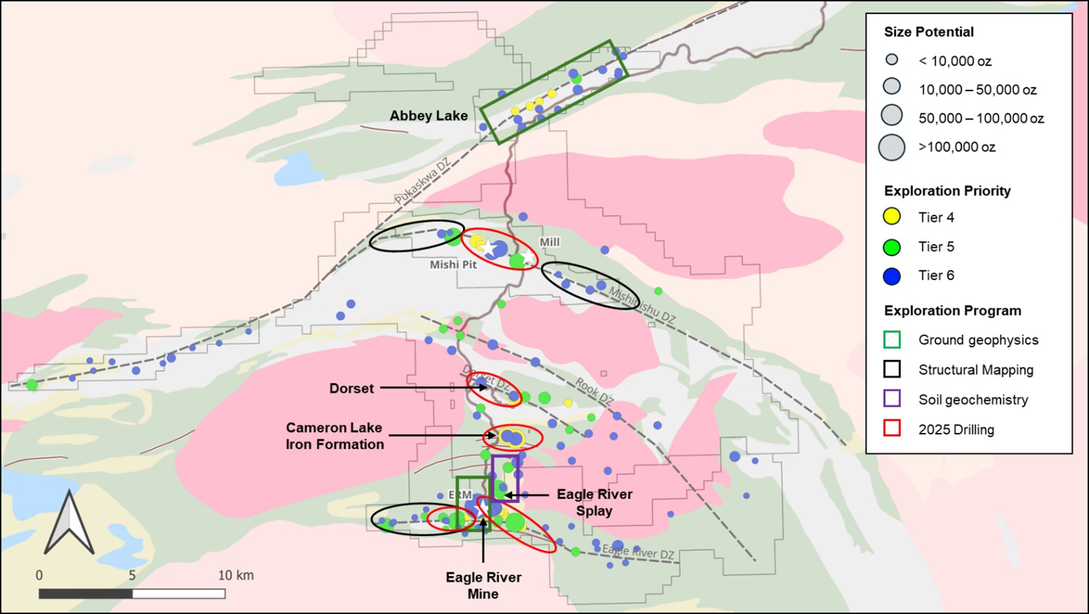
Figure 2: Mishi Long Section (Looking South)
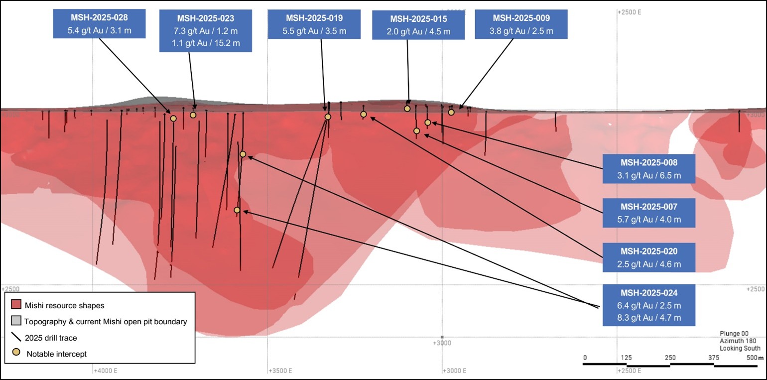
Figure 3: Dorset Zone Plan View
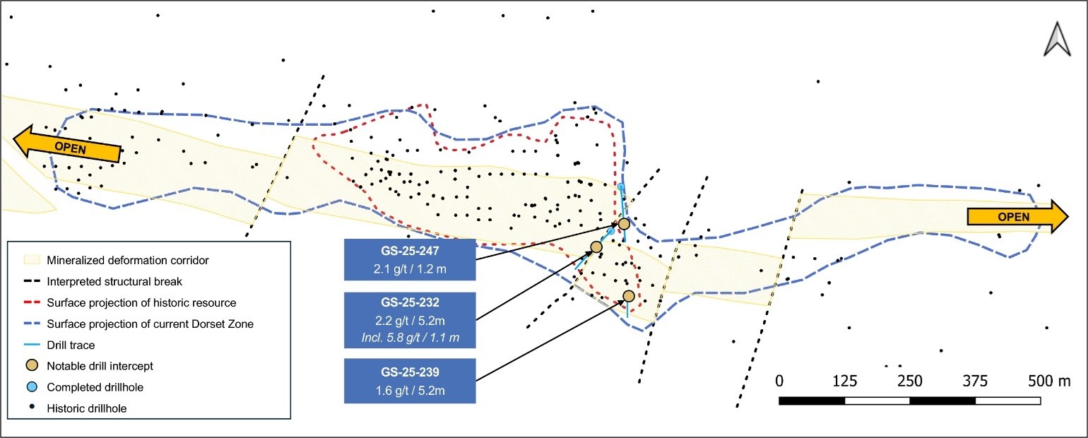
Figure 4: Falcon Zone Long Section (Looking North)
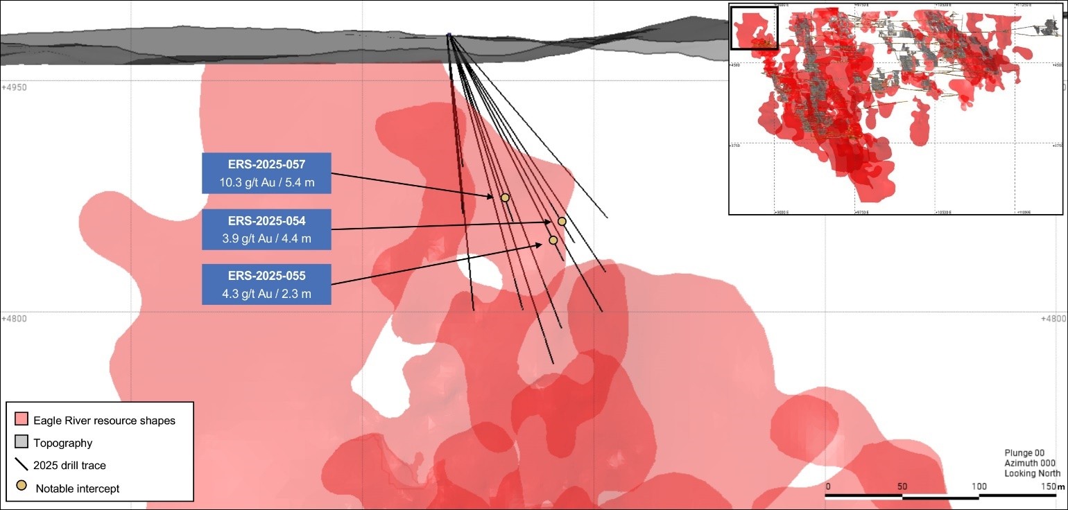
Figure 5: Cameron Lake Iron Formation Plan View
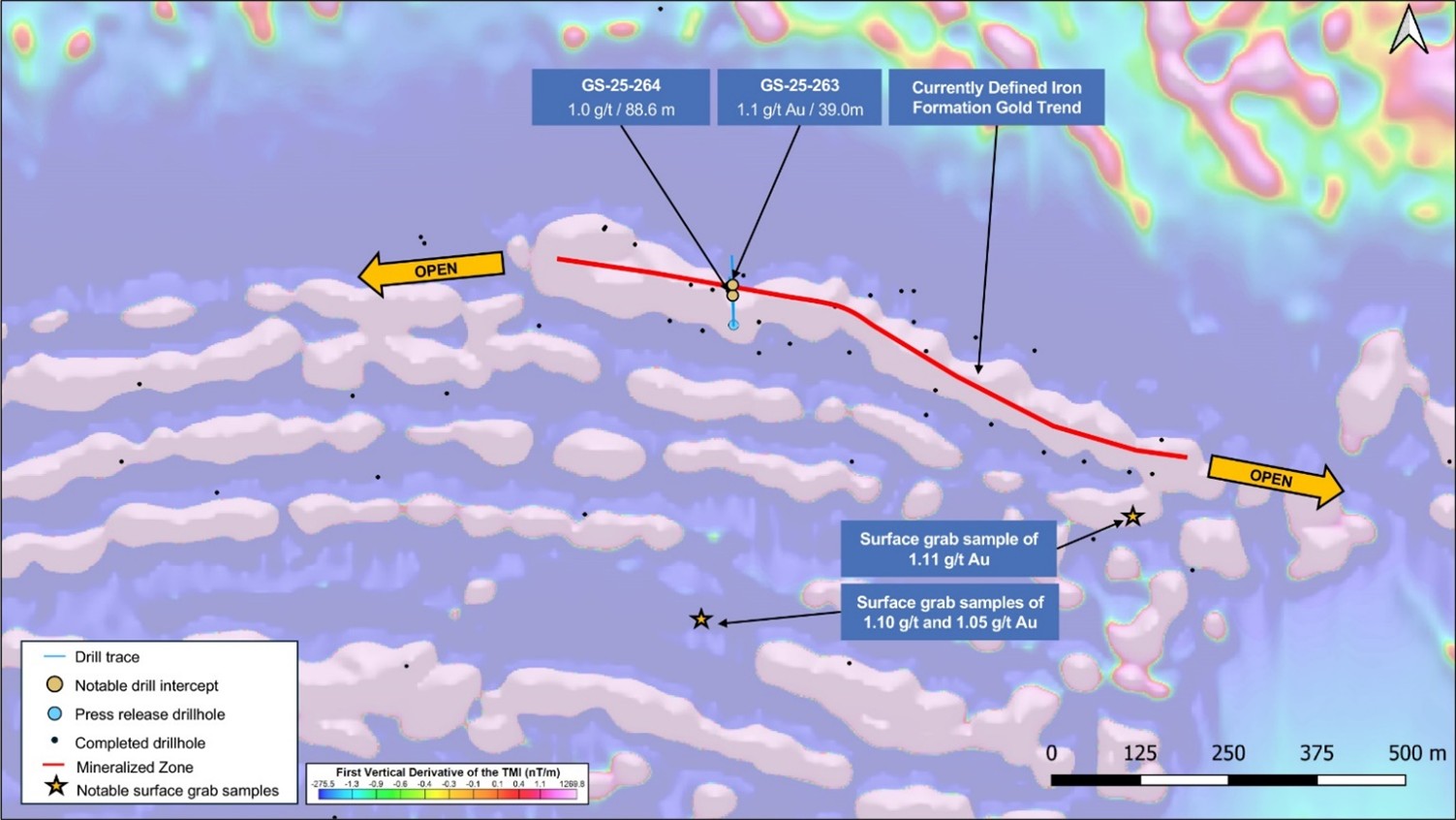
Figure 6: Mishibishu Deformation Zone Detailed Geological Map

Figure 7: Dorset Zone Longitudinal Section
The longitudinal section below illustrates the evolution of the geological interpretation based on new drilling. These shapes are conceptual grade-shell interpretations used internally for drill planning and do not represent a mineral resource estimate.
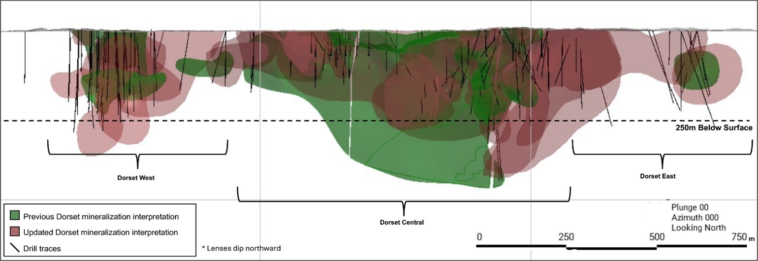
Table 1: Eagle River Drill Results (Previously Unreleased)
Composite Results
Figures in table may not add due to rounding
| Hole No. |
From (m) |
To (m) |
Core Length (m) |
Estimated True Width (m) |
Grade (g/t Au) |
Cut Grade (g/t Au) |
Target |
Mishi
| MSH-2025-007 | 73.5 | 77.5 | 4.0 | 3.9 | 5.7 | 5.7 | Mishi |
| MSH-2025-008 | 53.0 | 59.5 | 6.5 | 6.4 | 3.1 | 3.1 | Mishi |
| MSH-2025-009 | 29.5 | 32.0 | 2.5 | 2.5 | 3.8 | 3.8 | Mishi |
| MSH-2025-015 | 24.0 | 28.5 | 4.5 | 4.5 | 2.0 | 2.0 | Mishi |
| MSH-2025-019 | 19.6 | 23.0 | 3.5 | 3.4 | 5.5 | 5.5 | Mishi |
| MSH-2025-020 | 31.5 | 36.1 | 4.6 | 4.5 | 2.5 | 2.5 | Mishi |
| MSH-2025-021 | 66.8 | 67.4 | 0.6 | 0.6 | 6.0 | 6.0 | Mishi |
| MSH-2025-023 | 25.0 | 26.2 | 1.2 | 1.1 | 7.3 | 7.3 | Mishi |
| MSH-2025-023 | 56.0 | 71.2 | 15.2 | 14.3 | 1.1 | 1.1 | Mishi |
| MSH-2025-024 | 123.0 | 125.5 | 2.5 | 2.3 | 6.4 | 6.4 | Mishi |
| MSH-2025-024 | 305.4 | 311.0 | 5.6 | 5.3 | 2.5 | 2.5 | Mishi |
| MSH-2025-024 | 325.6 | 330.3 | 4.7 | 4.5 | 8.3 | 8.3 | Mishi |
| MSH-2025-025 | 297.5 | 309.4 | 11.9 | 11.7 | 0.9 | 0.9 | Mishi |
| MSH-2025-026 | 53.3 | 54.9 | 1.6 | 1.6 | 3.6 | 3.6 | Mishi |
| MSH-2025-028 | 61.0 | 64.1 | 3.1 | 2.7 | 5.4 | 5.4 | Mishi |
Cameron Lake Iron Formation
| GS-25-263 | 13.0 | 52.0 | 39.0 | 1.1 | Iron Formation | ||
| GS-25-263 | 84.7 | 85.7 | 1.0 | 1.4 | Iron Formation | ||
| GS-25-263 | 103.2 | 104.0 | 0.8 | 2.6 | Iron Formation | ||
| GS-25-264 | 17.2 | 105.8 | 88.6 | 1.0 | Iron Formation | ||
| GS-25-264 | 108.5 | 109.4 | 0.9 | 1.4 | Iron Formation | ||
| GS-25-264 | 113.1 | 114.1 | 1.0 | 1.9 | Iron Formation | ||
| GS-25-264 | 132.0 | 134.0 | 2.0 | 1.4 | Iron Formation | ||
| GS-25-265 | 43.0 | 44.0 | 1.0 | 6.5 | Iron Formation | ||
| GS-25-265 | 47.0 | 49.0 | 2.0 | 2.1 | Iron Formation | ||
| GS-25-265 | 54.0 | 55.0 | 1.0 | 1.3 | Iron Formation | ||
| GS-25-265 | 71.5 | 73.1 | 1.6 | 2.1 | Iron Formation | ||
| GS-25-265 | 85.0 | 86.0 | 1.0 | 2.3 | Iron Formation | ||
| GS-25-265 | 103.0 | 106.0 | 3.0 | 3.1 | Iron Formation | ||
| GS-25-265 | 114.0 | 123.0 | 9.0 | 1.2 | Iron Formation | ||
| GS-25-265 | 139.0 | 140.0 | 1.0 | 2.0 | Iron Formation | ||
| GS-25-265 | 195.6 | 197.2 | 1.6 | 2.1 | Iron Formation | ||
| GS-25-265 | 199.0 | 200.0 | 1.0 | 1.1 | Iron Formation | ||
| GS-25-265 | 204.0 | 205.0 | 1.0 | 1.2 | Iron Formation | ||
| GS-25-265 | 208.0 | 209.0 | 1.0 | 1.6 | Iron Formation | ||
| GS-25-265 | 212.0 | 213.0 | 1.0 | 1.6 | Iron Formation | ||
| GS-25-265 | 224.0 | 225.0 | 1.0 | 1.8 | Iron Formation |
| Hole No. |
From (m) |
To (m) |
Core Length (m) |
Estimated True Width (m) |
Grade (g/t Au) |
Cut Grade (g/t Au) |
Target |
Dorset Zone
| GS-25-232 | 88.9 | 94.1 | 5.2 | 2.2 | Dorset | ||
| GS-25-239 | 11.8 | 20.7 | 8.9 | 1.6 | Dorset | ||
| GS-25-247 | 216.2 | 217.4 | 1.2 | 4.1 | Dorset |
Falcon 720 Zone
| ERS-2025-043 | 46.5 | 47.0 | 0.5 | 0.4 | 5.2 | 5.2 | Falcon 720 |
| ERS-2025-049 | 143.0 | 144.0 | 1.0 | 0.6 | 6.8 | 6.8 | Falcon 720 |
| ERS-2025-050 | 147.0 | 151.0 | 4.0 | 2.3 | 1.6 | 1.6 | Falcon 720 |
| ERS-2025-054 | 136.0 | 140.4 | 4.4 | 3.3 | 3.9 | 3.9 | Falcon 720 |
| ERS-2025-055 | 152.2 | 154.5 | 2.3 | 1.6 | 4.3 | 4.3 | Falcon 720 |
| ERS-2025-057 | 135.0 | 140.4 | 5.4 | 4.0 | 10.0 | 10.0 | Falcon 720 |
Assay Results
Figures in table may not add due to rounding
| Hole No. |
From (m) |
To (m) |
Core Length (m) |
Grade (g/t Au) |
Cut Grade (g/t Au) |
Target |
| MSH-2025-007 | 73.5 | 74.0 | 0.5 | 4.3 | 4.3 | Mishi |
| MSH-2025-007 | 74.0 | 74.5 | 0.5 | 7.2 | 7.2 | Mishi |
| MSH-2025-007 | 74.5 | 75.0 | 0.5 | 3.5 | 3.5 | Mishi |
| MSH-2025-007 | 75.0 | 75.8 | 0.8 | 9.0 | 9.0 | Mishi |
| MSH-2025-007 | 75.8 | 76.5 | 0.8 | 1.6 | 1.6 | Mishi |
| MSH-2025-007 | 76.5 | 77.5 | 1.0 | 1.6 | 1.6 | Mishi |
| MSH-2025-008 | 53.0 | 54.0 | 1.0 | 5.0 | 5.0 | Mishi |
| MSH-2025-008 | 54.0 | 55.0 | 1.0 | 2.1 | 2.1 | Mishi |
| MSH-2025-008 | 55.0 | 56.0 | 1.0 | 1.4 | 1.4 | Mishi |
| MSH-2025-008 | 56.0 | 57.0 | 1.0 | 1.4 | 1.4 | Mishi |
| MSH-2025-008 | 57.0 | 58.0 | 1.0 | 2.9 | 2.9 | Mishi |
| MSH-2025-008 | 58.0 | 59.0 | 1.0 | 3.9 | 3.9 | Mishi |
| MSH-2025-008 | 59.0 | 59.5 | 0.5 | 7.3 | 7.3 | Mishi |
| MSH-2025-009 | 29.5 | 30.5 | 1.0 | 0.0 | 0.0 | Mishi |
| MSH-2025-009 | 30.5 | 31.0 | 0.5 | 4.5 | 4.5 | Mishi |
| MSH-2025-009 | 31.0 | 32.0 | 1.0 | 7.2 | 7.2 | Mishi |
| MSH-2025-019 | 19.6 | 20.2 | 0.6 | 0.0 | 0.0 | Mishi |
| MSH-2025-019 | 20.2 | 20.9 | 0.7 | 1.6 | 1.6 | Mishi |
| MSH-2025-019 | 20.9 | 21.3 | 0.4 | 0.4 | 0.4 | Mishi |
| MSH-2025-019 | 21.3 | 21.8 | 0.5 | 35.1 | 35.1 | Mishi |
| MSH-2025-024 | 123.0 | 124.0 | 1.0 | 0.2 | 0.2 | Mishi |
| MSH-2025-024 | 124.0 | 124.5 | 0.5 | 29.3 | 29.3 | Mishi |
| MSH-2025-024 | 124.5 | 125.5 | 1.0 | 1.1 | 1.1 | Mishi |
| MSH-2025-024 | 305.4 | 306.0 | 0.6 | 1.4 | 1.4 | Mishi |
| MSH-2025-024 | 306.0 | 307.0 | 0.9 | 1.5 | 1.5 | Mishi |
| MSH-2025-024 | 307.0 | 308.0 | 1.1 | 2.2 | 2.2 | Mishi |
| MSH-2025-024 | 308.0 | 309.0 | 1.0 | 3.7 | 3.7 | Mishi |
| MSH-2025-024 | 309.0 | 309.5 | 0.5 | 7.3 | 7.3 | Mishi |
| MSH-2025-024 | 309.5 | 310.5 | 1.0 | 1.4 | 1.4 | Mishi |
| MSH-2025-024 | 310.5 | 311.0 | 0.5 | 1.4 | 1.4 | Mishi |
| MSH-2025-024 | 325.6 | 326.2 | 0.6 | 1.8 | 1.8 | Mishi |
| MSH-2025-024 | 326.2 | 327.2 | 1.0 | 0.6 | 0.6 | Mishi |
| MSH-2025-024 | 327.2 | 328.2 | 1.0 | 16.3 | 16.3 | Mishi |
| MSH-2025-024 | 328.2 | 329.1 | 0.9 | 18.3 | 18.3 | Mishi |
| MSH-2025-024 | 329.1 | 329.6 | 0.6 | 8.1 | 8.1 | Mishi |
| MSH-2025-024 | 329.6 | 330.3 | 0.7 | 1.3 | 1.3 | Mishi |
| MSH-2025-028 | 61.0 | 61.5 | 0.5 | 0.6 | 0.6 | Mishi |
| MSH-2025-028 | 61.5 | 62.0 | 0.5 | 0.5 | 0.5 | Mishi |
| MSH-2025-028 | 62.0 | 62.6 | 0.6 | 0.2 | 0.2 | Mishi |
| MSH-2025-028 | 62.6 | 63.2 | 0.5 | 0.4 | 0.4 | Mishi |
| MSH-2025-028 | 63.2 | 63.7 | 0.5 | 2.8 | 2.8 | Mishi |
| MSH-2025-028 | 63.7 | 64.1 | 0.4 | 32.6 | 32.6 | Mishi |
| GS-25-209 | 169.5 | 171.0 | 1.5 | 10.9 | Dorset | |
| GS-25-209 | 171.0 | 172.5 | 1.5 | 0.4 | Dorset | |
| GS-25-232 | 88.9 | 90.0 | 1.1 | 1.2 | Dorset | |
| GS-25-232 | 90.0 | 91.0 | 1.0 | 0.5 | Dorset | |
| GS-25-232 | 91.0 | 92.0 | 1.0 | 1.4 | Dorset | |
| GS-25-232 | 92.0 | 93.0 | 1.0 | 1.9 | Dorset | |
| GS-25-232 | 93.0 | 94.1 | 1.1 | 5.8 | Dorset | |
| GS-25-239 | 11.8 | 12.8 | 1.0 | 2.7 | Dorset | |
| GS-25-239 | 12.8 | 13.8 | 1.0 | 1.5 | Dorset | |
| GS-25-239 | 13.8 | 14.8 | 1.0 | 0.2 | Dorset | |
| GS-25-239 | 14.8 | 15.8 | 1.0 | 0.6 | Dorset | |
| GS-25-239 | 15.8 | 16.8 | 1.0 | 1.8 | Dorset | |
| GS-25-239 | 16.8 | 17.8 | 1.0 | 2.6 | Dorset | |
| GS-25-239 | 17.8 | 18.8 | 1.0 | 0.3 | Dorset | |
| GS-25-239 | 18.8 | 19.8 | 1.0 | 3.8 | Dorset | |
| GS-25-239 | 19.8 | 20.7 | 0.9 | 1.2 | Dorset | |
| GS-25-247 | 216.2 | 216.8 | 0.6 | 1.9 | Dorset | |
| GS-25-247 | 216.8 | 217.4 | 0.6 | 6.2 | Dorset | |
| GS-25-263 | 13.0 | 14.0 | 1.0 | 0.8 | Iron Formation | |
| GS-25-263 | 14.0 | 15.0 | 1.0 | 0.5 | Iron Formation | |
| GS-25-263 | 15.0 | 15.7 | 0.7 | 1.3 | Iron Formation | |
| GS-25-263 | 15.7 | 16.6 | 0.9 | 0.1 | Iron Formation | |
| GS-25-263 | 16.6 | 17.5 | 0.9 | 0.0 | Iron Formation | |
| GS-25-263 | 17.5 | 18.4 | 0.9 | 0.0 | Iron Formation | |
| GS-25-263 | 18.4 | 19.3 | 0.9 | 0.5 | Iron Formation | |
| GS-25-263 | 19.3 | 20.2 | 0.9 | 1.3 | Iron Formation | |
| GS-25-263 | 20.2 | 21.0 | 0.8 | 1.9 | Iron Formation | |
| GS-25-263 | 21.0 | 22.0 | 1.0 | 1.6 | Iron Formation | |
| GS-25-263 | 22.0 | 23.0 | 1.0 | 0.2 | Iron Formation | |
| GS-25-263 | 23.0 | 24.0 | 1.0 | 0.3 | Iron Formation | |
| GS-25-263 | 24.0 | 25.1 | 1.1 | 0.0 | Iron Formation | |
| GS-25-263 | 25.1 | 26.2 | 1.1 | 0.0 | Iron Formation | |
| GS-25-263 | 26.2 | 27.0 | 0.8 | 0.4 | Iron Formation | |
| GS-25-263 | 27.0 | 28.0 | 1.0 | 3.7 | Iron Formation | |
| GS-25-263 | 28.0 | 28.7 | 0.7 | 1.3 | Iron Formation | |
| GS-25-263 | 28.7 | 29.5 | 0.8 | 0.2 | Iron Formation | |
| GS-25-263 | 29.5 | 30.3 | 0.8 | 0.7 | Iron Formation | |
| GS-25-263 | 30.3 | 31.2 | 0.9 | 0.7 | Iron Formation | |
| GS-25-263 | 31.2 | 32.0 | 0.8 | 0.8 | Iron Formation | |
| GS-25-263 | 32.0 | 33.0 | 1.0 | 0.7 | Iron Formation | |
| GS-25-263 | 33.0 | 34.0 | 1.0 | 3.3 | Iron Formation | |
| GS-25-263 | 34.0 | 35.0 | 1.0 | 1.2 | Iron Formation | |
| GS-25-263 | 35.0 | 36.0 | 1.0 | 2.1 | Iron Formation | |
| GS-25-263 | 36.0 | 37.0 | 1.0 | 2.0 | Iron Formation | |
| GS-25-263 | 37.0 | 38.0 | 1.0 | 2.5 | Iron Formation | |
| GS-25-263 | 38.0 | 39.0 | 1.0 | 1.1 | Iron Formation | |
| GS-25-263 | 39.0 | 40.0 | 1.0 | 1.6 | Iron Formation | |
| GS-25-263 | 40.0 | 41.0 | 1.0 | 2.1 | Iron Formation | |
| GS-25-263 | 41.0 | 42.0 | 1.0 | 0.6 | Iron Formation | |
| GS-25-263 | 42.0 | 43.0 | 1.0 | 0.5 | Iron Formation | |
| GS-25-263 | 43.0 | 44.0 | 1.0 | 1.2 | Iron Formation | |
| GS-25-263 | 44.0 | 45.0 | 1.0 | 1.4 | Iron Formation | |
| GS-25-263 | 45.0 | 46.0 | 1.0 | 0.1 | Iron Formation | |
| GS-25-263 | 46.0 | 47.0 | 1.0 | 0.7 | Iron Formation | |
| GS-25-263 | 47.0 | 48.0 | 1.0 | 1.3 | Iron Formation | |
| GS-25-263 | 48.0 | 49.0 | 1.0 | 1.0 | Iron Formation | |
| GS-25-263 | 49.0 | 50.0 | 1.0 | 1.2 | Iron Formation | |
| GS-25-263 | 50.0 | 51.0 | 1.0 | 1.0 | Iron Formation | |
| GS-25-263 | 51.0 | 52.0 | 1.0 | 1.2 | Iron Formation | |
| GS-25-263 | 84.7 | 85.7 | 1.0 | 1.4 | Iron Formation | |
| GS-25-263 | 103.2 | 104.0 | 0.8 | 2.6 | Iron Formation | |
| GS-25-264 | 17.2 | 18.0 | 0.8 | 5.6 | Iron Formation | |
| GS-25-264 | 18.0 | 19.0 | 1.0 | 0.6 | Iron Formation | |
| GS-25-264 | 19.0 | 20.0 | 1.0 | 0.3 | Iron Formation | |
| GS-25-264 | 20.0 | 21.0 | 1.0 | 0.2 | Iron Formation | |
| GS-25-264 | 21.0 | 22.0 | 1.0 | 0.8 | Iron Formation | |
| GS-25-264 | 22.0 | 23.0 | 1.0 | 0.8 | Iron Formation | |
| GS-25-264 | 23.0 | 24.0 | 1.0 | 0.9 | Iron Formation | |
| GS-25-264 | 24.0 | 25.0 | 1.0 | 0.3 | Iron Formation | |
| GS-25-264 | 25.0 | 26.0 | 1.0 | 0.1 | Iron Formation | |
| GS-25-264 | 26.0 | 27.0 | 1.0 | 2.4 | Iron Formation | |
| GS-25-264 | 27.0 | 28.0 | 1.0 | 0.1 | Iron Formation | |
| GS-25-264 | 28.0 | 29.0 | 1.0 | 1.1 | Iron Formation | |
| GS-25-264 | 29.0 | 30.0 | 1.0 | 1.1 | Iron Formation | |
| GS-25-264 | 30.0 | 31.0 | 1.0 | 0.6 | Iron Formation | |
| GS-25-264 | 31.0 | 32.0 | 1.0 | 1.4 | Iron Formation | |
| GS-25-264 | 32.0 | 33.0 | 1.0 | 0.6 | Iron Formation | |
| GS-25-264 | 33.0 | 34.0 | 1.0 | 2.4 | Iron Formation | |
| GS-25-264 | 34.0 | 35.0 | 1.0 | 7.5 | Iron Formation | |
| GS-25-264 | 35.0 | 36.0 | 1.0 | 1.1 | Iron Formation | |
| GS-25-264 | 36.0 | 37.0 | 1.0 | 0.4 | Iron Formation | |
| GS-25-264 | 37.0 | 38.0 | 1.0 | 1.4 | Iron Formation | |
| GS-25-264 | 38.0 | 39.0 | 1.0 | 0.5 | Iron Formation | |
| GS-25-264 | 39.0 | 40.0 | 1.0 | 0.1 | Iron Formation | |
| GS-25-264 | 40.0 | 40.9 | 0.9 | 0.0 | Iron Formation | |
| GS-25-264 | 40.9 | 41.7 | 0.8 | 0.0 | Iron Formation | |
| GS-25-264 | 41.7 | 42.5 | 0.8 | 0.0 | Iron Formation | |
| GS-25-264 | 42.5 | 43.3 | 0.8 | 0.0 | Iron Formation | |
| GS-25-264 | 43.3 | 44.1 | 0.8 | 0.4 | Iron Formation | |
| GS-25-264 | 44.1 | 44.8 | 0.7 | 1.6 | Iron Formation | |
| GS-25-264 | 44.8 | 45.8 | 1.0 | 0.9 | Iron Formation | |
| GS-25-264 | 45.8 | 46.6 | 0.8 | 0.0 | Iron Formation | |
| GS-25-264 | 46.6 | 47.4 | 0.8 | 0.1 | Iron Formation | |
| GS-25-264 | 47.4 | 48.2 | 0.8 | 1.7 | Iron Formation | |
| GS-25-264 | 48.2 | 49.0 | 0.8 | 1.7 | Iron Formation | |
| GS-25-264 | 49.0 | 50.0 | 1.0 | 2.0 | Iron Formation | |
| GS-25-264 | 50.0 | 51.0 | 1.0 | 1.3 | Iron Formation | |
| GS-25-264 | 51.0 | 52.0 | 1.0 | 1.4 | Iron Formation | |
| GS-25-264 | 52.0 | 53.0 | 1.0 | 1.2 | Iron Formation | |
| GS-25-264 | 53.0 | 54.0 | 1.0 | 0.6 | Iron Formation | |
| GS-25-264 | 54.0 | 55.0 | 1.0 | 1.0 | Iron Formation | |
| GS-25-264 | 55.0 | 56.0 | 1.0 | 1.5 | Iron Formation | |
| GS-25-264 | 56.0 | 57.0 | 1.0 | 2.7 | Iron Formation | |
| GS-25-264 | 57.0 | 58.0 | 1.0 | 3.8 | Iron Formation | |
| GS-25-264 | 58.0 | 59.0 | 1.0 | 1.3 | Iron Formation | |
| GS-25-264 | 59.0 | 60.0 | 1.0 | 1.3 | Iron Formation | |
| GS-25-264 | 60.0 | 61.0 | 1.0 | 0.5 | Iron Formation | |
| GS-25-264 | 61.0 | 62.0 | 1.0 | 1.1 | Iron Formation | |
| GS-25-264 | 62.0 | 63.0 | 1.0 | 0.2 | Iron Formation | |
| GS-25-264 | 63.0 | 64.0 | 1.0 | 1.6 | Iron Formation | |
| GS-25-264 | 64.0 | 65.0 | 1.0 | 1.0 | Iron Formation | |
| GS-25-264 | 65.0 | 66.0 | 1.0 | 0.0 | Iron Formation | |
| GS-25-264 | 66.0 | 67.0 | 1.0 | 0.3 | Iron Formation | |
| GS-25-264 | 67.0 | 68.0 | 1.0 | 0.5 | Iron Formation | |
| GS-25-264 | 68.0 | 69.0 | 1.0 | 2.2 | Iron Formation | |
| GS-25-264 | 69.0 | 70.0 | 1.0 | 0.5 | Iron Formation | |
| GS-25-264 | 70.0 | 71.0 | 1.0 | 4.0 | Iron Formation | |
| GS-25-264 | 71.0 | 71.7 | 0.7 | 0.8 | Iron Formation | |
| GS-25-264 | 71.7 | 72.5 | 0.8 | 0.7 | Iron Formation | |
| GS-25-264 | 72.5 | 73.3 | 0.8 | 0.9 | Iron Formation | |
| GS-25-264 | 73.3 | 74.0 | 0.7 | 0.0 | Iron Formation | |
| GS-25-264 | 74.0 | 75.0 | 1.0 | 0.0 | Iron Formation | |
| GS-25-264 | 75.0 | 76.0 | 1.0 | 0.0 | Iron Formation | |
| GS-25-264 | 76.0 | 77.0 | 1.0 | 0.0 | Iron Formation | |
| GS-25-264 | 77.0 | 78.0 | 1.0 | 0.7 | Iron Formation | |
| GS-25-264 | 78.0 | 79.0 | 1.0 | 0.7 | Iron Formation | |
| GS-25-264 | 79.0 | 80.0 | 1.0 | 2.2 | Iron Formation | |
| GS-25-264 | 80.0 | 81.0 | 1.0 | 1.8 | Iron Formation | |
| GS-25-264 | 81.0 | 82.0 | 1.0 | 0.4 | Iron Formation | |
| GS-25-264 | 82.0 | 83.0 | 1.0 | 0.0 | Iron Formation | |
| GS-25-264 | 83.0 | 84.0 | 1.0 | 0.2 | Iron Formation | |
| GS-25-264 | 84.0 | 85.0 | 1.0 | 0.1 | Iron Formation | |
| GS-25-264 | 85.0 | 86.0 | 1.0 | 0.6 | Iron Formation | |
| GS-25-264 | 86.0 | 87.0 | 1.0 | 0.9 | Iron Formation | |
| GS-25-264 | 87.0 | 88.0 | 1.0 | 3.5 | Iron Formation | |
| GS-25-264 | 88.0 | 89.0 | 1.0 | 0.5 | Iron Formation | |
| GS-25-264 | 89.0 | 90.0 | 1.0 | 1.2 | Iron Formation | |
| GS-25-264 | 90.0 | 91.0 | 1.0 | 0.2 | Iron Formation | |
| GS-25-264 | 91.0 | 92.0 | 1.0 | 0.3 | Iron Formation | |
| GS-25-264 | 92.0 | 93.0 | 1.0 | 0.5 | Iron Formation | |
| GS-25-264 | 93.0 | 94.0 | 1.0 | 0.1 | Iron Formation | |
| GS-25-264 | 94.0 | 95.0 | 1.0 | 0.1 | Iron Formation | |
| GS-25-264 | 95.0 | 96.0 | 1.0 | 0.1 | Iron Formation | |
| GS-25-264 | 96.0 | 97.0 | 1.0 | 0.1 | Iron Formation | |
| GS-25-264 | 97.0 | 98.0 | 1.0 | 0.2 | Iron Formation | |
| GS-25-264 | 98.0 | 99.0 | 1.0 | 0.1 | Iron Formation | |
| GS-25-264 | 99.0 | 100.0 | 1.0 | 0.1 | Iron Formation | |
| GS-25-264 | 100.0 | 101.0 | 1.0 | 0.1 | Iron Formation | |
| GS-25-264 | 101.0 | 102.0 | 1.0 | 0.1 | Iron Formation | |
| GS-25-264 | 102.0 | 103.0 | 1.0 | 1.3 | Iron Formation | |
| GS-25-264 | 103.0 | 104.0 | 1.0 | 0.8 | Iron Formation | |
| GS-25-264 | 104.0 | 105.0 | 1.0 | 0.4 | Iron Formation | |
| GS-25-264 | 105.0 | 105.8 | 0.8 | 1.0 | Iron Formation | |
| GS-25-264 | 108.5 | 109.4 | 0.9 | 1.4 | Iron Formation | |
| GS-25-264 | 113.1 | 114.1 | 1.0 | 1.9 | Iron Formation | |
| GS-25-264 | 132.0 | 133.0 | 1.0 | 1.5 | Iron Formation | |
| GS-25-264 | 133.0 | 134.0 | 1.0 | 1.3 | Iron Formation | |
| GS-25-265 | 43.0 | 44.0 | 1.0 | 6.5 | Iron Formation | |
| GS-25-265 | 47.0 | 48.0 | 1.0 | 3.1 | Iron Formation | |
| GS-25-265 | 48.0 | 49.0 | 1.0 | 1.1 | Iron Formation | |
| GS-25-265 | 54.0 | 55.0 | 1.0 | 1.3 | Iron Formation | |
| GS-25-265 | 71.5 | 72.3 | 0.8 | 1.7 | Iron Formation | |
| GS-25-265 | 72.3 | 73.1 | 0.8 | 2.6 | Iron Formation | |
| GS-25-265 | 85.0 | 86.0 | 1.0 | 2.3 | Iron Formation | |
| GS-25-265 | 103.0 | 104.0 | 1.0 | 1.3 | Iron Formation | |
| GS-25-265 | 104.0 | 105.0 | 1.0 | 3.6 | Iron Formation | |
| GS-25-265 | 105.0 | 106.0 | 1.0 | 1.4 | Iron Formation | |
| GS-25-265 | 114.0 | 115.0 | 1.0 | 0.7 | Iron Formation | |
| GS-25-265 | 115.0 | 116.0 | 1.0 | 1.6 | Iron Formation | |
| GS-25-265 | 116.0 | 117.0 | 1.0 | 2.9 | Iron Formation | |
| GS-25-265 | 117.0 | 118.0 | 1.0 | 0.1 | Iron Formation | |
| GS-25-265 | 118.0 | 119.0 | 1.0 | 0.9 | Iron Formation | |
| GS-25-265 | 119.0 | 120.0 | 1.0 | 1.8 | Iron Formation | |
| GS-25-265 | 120.0 | 121.0 | 1.0 | 2.0 | Iron Formation | |
| GS-25-265 | 121.0 | 122.0 | 1.0 | 0.1 | Iron Formation | |
| GS-25-265 | 122.0 | 123.0 | 1.0 | 0.8 | Iron Formation | |
| GS-25-265 | 139.0 | 140.0 | 1.0 | 2.0 | Iron Formation | |
| GS-25-265 | 195.6 | 196.4 | 0.8 | 3.0 | Iron Formation | |
| GS-25-265 | 196.4 | 197.2 | 0.8 | 1.3 | Iron Formation | |
| GS-25-265 | 199.0 | 200.0 | 1.0 | 1.1 | Iron Formation | |
| GS-25-265 | 204.0 | 205.0 | 1.0 | 1.2 | Iron Formation | |
| GS-25-265 | 208.0 | 209.0 | 1.0 | 1.6 | Iron Formation | |
| GS-25-265 | 212.0 | 213.0 | 1.0 | 1.6 | Iron Formation | |
| GS-25-265 | 224.0 | 225.0 | 1.0 | 1.8 | Iron Formation | |
| ERS-2025-043 | 46.5 | 47.0 | 0.5 | 5.2 | 5.2 | Upper Falcon 720 |
| ERS-2025-049 | 143.0 | 144.0 | 1.0 | 6.8 | 6.8 | Upper Falcon 720 |
| ERS-2025-050 | 147.0 | 147.9 | 0.9 | 1.3 | 1.3 | Upper Falcon 720 |
| ERS-2025-050 | 147.9 | 148.7 | 0.8 | 0.1 | 0.1 | Upper Falcon 720 |
| ERS-2025-050 | 148.7 | 149.3 | 0.5 | 0.1 | 0.1 | Upper Falcon 720 |
| ERS-2025-050 | 149.3 | 150.1 | 0.8 | 4.0 | 4.0 | Upper Falcon 720 |
| ERS-2025-050 | 150.1 | 151.0 | 0.9 | 1.6 | 1.6 | Upper Falcon 720 |
| ERS-2025-054 | 136.0 | 137.0 | 1.0 | 8.3 | 8.3 | Upper Falcon 720 |
| ERS-2025-054 | 137.0 | 137.8 | 0.8 | 0.1 | 0.1 | Upper Falcon 720 |
| ERS-2025-054 | 137.8 | 138.8 | 1.0 | 0.1 | 0.1 | Upper Falcon 720 |
| ERS-2025-054 | 138.8 | 139.8 | 1.0 | 5.7 | 5.7 | Upper Falcon 720 |
| ERS-2025-054 | 139.8 | 140.4 | 0.6 | 5.2 | 5.2 | Upper Falcon 720 |
| ERS-2025-055 | 152.2 | 153.0 | 0.8 | 2.7 | 2.7 | Upper Falcon 720 |
| ERS-2025-055 | 153.0 | 153.5 | 0.5 | 7.9 | 7.9 | Upper Falcon 720 |
| ERS-2025-055 | 153.5 | 154.0 | 0.5 | 6.6 | 6.6 | Upper Falcon 720 |
| ERS-2025-055 | 154.0 | 154.5 | 0.5 | 1.1 | 1.1 | Upper Falcon 720 |
| ERS-2025-057 | 135.0 | 135.6 | 0.6 | 1.7 | 1.7 | Upper Falcon 720 |
| ERS-2025-057 | 135.6 | 136.6 | 1.0 | 0.1 | 0.1 | Upper Falcon 720 |
| ERS-2025-057 | 136.6 | 137.3 | 0.7 | 1.4 | 1.4 | Upper Falcon 720 |
| ERS-2025-057 | 137.3 | 138.0 | 0.7 | 5.8 | 5.8 | Upper Falcon 720 |
| ERS-2025-057 | 138.0 | 138.6 | 0.6 | 68.4 | 68.4 | Upper Falcon 720 |
| ERS-2025-057 | 138.6 | 139.3 | 0.7 | 8.1 | 8.1 | Upper Falcon 720 |
| ERS-2025-057 | 139.3 | 139.9 | 0.6 | 1.3 | 1.3 | Upper Falcon 720 |
| ERS-2025-057 | 139.9 | 140.4 | 0.5 | 1.5 | 1.5 | Upper Falcon 720 |
*Given that there is no conceptual geological model for Dorset or the Cameron Lake Iron Formation, neither true width nor top cuts have been defined.
Figures accompanying this announcement are available at:
https://www.globenewswire.com/NewsRoom/AttachmentNg/3d6ebae3-3e9a-470b-afc6-e876a26e6222
https://www.globenewswire.com/NewsRoom/AttachmentNg/b81ff6ed-018a-461e-a9ad-b963ea7da3ff
https://www.globenewswire.com/NewsRoom/AttachmentNg/a868eb93-bc97-4bf7-aa86-705b46fcb077
https://www.globenewswire.com/NewsRoom/AttachmentNg/342c32e1-dc86-4808-bad2-213e14d30f2a
https://www.globenewswire.com/NewsRoom/AttachmentNg/13a8a4fd-1115-4401-b266-24723a3cf083
https://www.globenewswire.com/NewsRoom/AttachmentNg/2c986790-9584-4557-a51a-f494b052ae2d
https://www.globenewswire.com/NewsRoom/AttachmentNg/210bee95-6a98-4fbc-be09-cfc84a8671bb
PDF available: http://ml.globenewswire.com/Resource/Download/07af1234-60a1-45e9-a166-0741f31afd0b

![]()
Figure 1
Eagle River 2025 Regional Work Plan
Figure 2

Mishi Long Section (Looking South)
Figure 3

Dorset Zone Plan View
Figure 4
Falcon Zone Long Section (Looking North)
Figure 5

Cameron Lake Iron Formation Plan View
Figure 6
Mishibishu Deformation Zone Detailed Geological Map
Figure 7
Dorset Zone Longitudinal Section
Legal Disclaimer:
EIN Presswire provides this news content "as is" without warranty of any kind. We do not accept any responsibility or liability for the accuracy, content, images, videos, licenses, completeness, legality, or reliability of the information contained in this article. If you have any complaints or copyright issues related to this article, kindly contact the author above.
